
A Little History
This stretch of coast holds real stories — a Famine-era mill, and two dramatic shipwrecks on the coves either side of the property.
The Mill
The Mill takes its name from the three-storey flour mill at its heart, built in the 1840s, likely as a Famine relief project, and powered by the stream that still runs through the grounds. Corn was ground here until the wheel fell silent over a century ago; it is long gone now, though you can still see where it once sat. The building stood roofless and overgrown until it was rescued and rebuilt as a home in the mid-1990s, reusing reclaimed Portland stone steps from nearby Hodderfield House and pitch-pine timbers from an old church, before a further renovation in 2022 opened it up to the light.
A Name Older Than the Wreck
Rennies, like almost every field and townland in this part of Cork, carries a name far older than any of the events on this page. Historical records trace it to Teach na Reann — "House of the Point," from teach (house) and rinn (a point or headland) — though the nineteenth-century placename scholar John O’Donovan noted that "Reanie" may equally be an old family surname rather than a direct translation of the Irish. The name appears in records stretching back to the 1580s, under spellings including Reanes (1588), Reanies (1611), Reyny (1618) and Renish (1655). Whichever reading is right, the name was already centuries old by the time the Rockingham went down in the bay that bears it.
Nohoval itself comes from the Irish Nuachabháil, meaning "new settlement" — itself an old name marking what was, once, a new one. Irish townlands were fixed as a system of land division long before the Anglo-Norman arrival in the twelfth century, and the names attached to them are older still: a way of recording, field by field, what the land was used for, who farmed it, what stood on it or grew on it, long before any map was drawn.
We don’t have to take that on faith. In 1937, as part of a national project sending schoolchildren out to record the folklore of their own townlands, pupils at the local Rennies national school collected the names their own parents used for the ground around them. Eugene Desmond wrote down the field names his mother Hannah gave him: Clais Ruadh, Cnoc Gaotha ("the hill of the wind"), Tobar an Abhráin ("the well of the song"), The Latrac, The Mash, The Barracks, The Mallach, An Cuilín, and more. A few fields away, Sheila Ahern recorded the names in use around Reagrove and Tracton: Faill Briste ("the broken cliff"), An Cnoc Dubh ("the black hill"), Páirc na Lúaithe, Baile Salach, and simple working names like The Long Field, The Orchard Field and The Well’s Field. None of these were invented for a map — they were what the people who worked this ground called it, and by 1937 they were already old enough that a schoolchild had to ask a parent what they meant.
Ringforts and Raths: The Older Landscape
Look closely at the fields around Rennies and you’re looking at one of the most densely settled landscapes in prehistoric and early medieval Europe. Ireland has somewhere between 40,000 and 50,000 surviving ringforts — circular farmstead enclosures thrown up, in most cases, between roughly 540 and 900 AD — at an average density of about one every two square kilometres. Most were the enclosed farmyards of ordinary, reasonably prosperous early medieval families: a bank and ditch around a cluster of houses, built to keep livestock in and casual raiders out, not fortresses in any grand military sense.
The names they left behind still label the map. Ráth and lios both describe an earthen ringfort — strictly, the ráth is the enclosing bank and the lios the open space inside it — while caiseal and cathair mark a stone-built version, and dún denotes any stronghold of significance, ringfort or not. The immediate neighbour to Nohoval, the townland of Dunbogey, is a case in point: in Irish, Dún Buaige, "Bogue’s fort," appearing in records back to 1601. The nineteenth-century Ordnance Survey noted a fort still standing at its north-east corner, describing it as a "Danish fort" — Viking, early medieval Irish, or older again, it’s exactly the kind of unmarked, overgrown earthwork that sits quietly in a corner of a field a few minutes from the house.
Tracton Abbey — Eight Centuries of Parish History
Nohoval’s own parish history is bound up with one of south Cork’s more significant medieval foundations. Around 1224–25, a party of Cistercian monks — sailing, by tradition, from Wales, and very likely landing on the shore at Ringabella before moving inland — founded Tracton Abbey under the patronage of the McCarthys. The likely site of the original abbey survives as a scatter of stones on a farm in the townland of Tubrid, near present-day Ballyfeard.
For several centuries the abbey was a genuine pilgrimage destination: contemporary accounts describe large crowds gathering every Holy Thursday to venerate a relic kept there. It didn’t survive the Reformation. Its lands were granted to new proprietors under Elizabeth I in 1568 and eventually passed into the Earl of Shannon’s estate; by the 1600s almost nothing of the original buildings remained standing. A handful of remarkable objects associated with the abbey have outlived the building itself — a silver chalice gifted in 1680, one of only ten sheela-na-gig carvings recorded in County Cork, and an Iron Age horse-bit roughly 2,200 years old, now held in the National Museum of Scotland.
The connection to this house is direct rather than incidental. Nohoval was historically administered as part of the same Roman Catholic parish union as Tracton, alongside Kilpatrick, Ballyfoyle and Kinnure. That link is still marked today: the abbey’s 800th anniversary was celebrated with a Mass at Sacred Heart Church, Minane Bridge, in September 2025, and the commemorations included prayers held at graveyards right across the old union — Nohoval cemetery among them.
Rennies Bay, 1775 — The Wreck of the Rockingham
On the night of 23 December 1775, the transport ship Rockingham was making for the shelter of Cork Harbour in a heavy gale, carrying three companies of the 32nd Regiment of Foot, along with a number of their wives and children, bound for Ireland en route to reinforce General Cornwallis’s army in North America. In the dark and the storm her master mistook Robert’s Cove for the entrance to the harbour and drove the ship onto a lee shore in the bay now known as Rennies. An estimated ninety of those aboard drowned that night — soldiers, wives and children among them — while contemporary accounts put the number who scrambled ashore at somewhere between thirty and thirty-five. The regiment’s own pay chest and records went down with the ship and were never recovered.
Man of War Cove, 1915 — The Sinking of the SS El Zorro
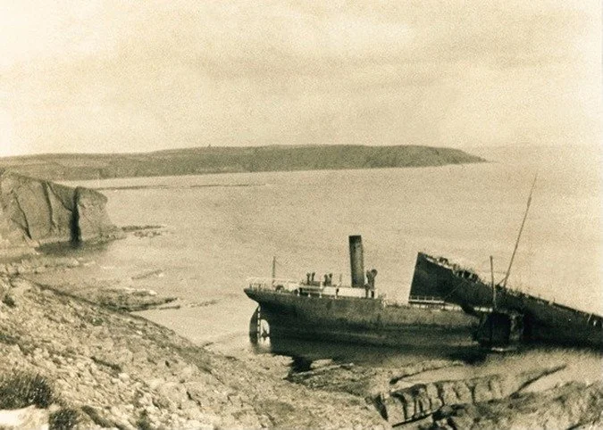
A century and a half after the Rockingham, the coast claimed another ship. SS El Zorro was a steel oil tanker of 5,989 gross tons, built by Swan, Hunter & Wigham Richardson on the Tyne, launched in January 1914 and registered that February to Lobitos Oilfields Ltd, and requisitioned by the Admiralty for the duration of the war. On 28 December 1915, on a run from Port Arthur, Texas, to Dartmouth with a full cargo of oil, she was struck by torpedoes from the German submarine U-24 as she approached Cork, under the command of Kapitänleutnant Rudolf Schneider — the same commander who had sunk the passenger liner Arabic only months before. El Zorro was one of five ships U-24 sank in a single week that December, off this same stretch of coast.
Her crew abandoned ship and were picked up by the armed trawler Freesia; the tanker herself was taken under tow by the armed yacht Greta, sent out from Kinsale to try to save her. She didn’t make it. A severe gale finished what the torpedoes had started, breaking the tow and driving the wreck ashore at Man o’ War Cove, where she broke in two — wrecked and abandoned in the cove in January 1916 — a photograph of the wreck taken not long after appears at the top of this page. Her cargo of 8,000 tons of crude oil coated the beaches for miles around, and two of her crew were lost. The wreck came to rest in almost the same waters where, only seven months earlier, on 7 May 1915, U-20 had torpedoed the Lusitania some eleven nautical miles off the Old Head. Perhaps fittingly, given what follows, Man o’ War Cove has long carried a second, unofficial name locally: Smuggler’s Cove.
What the Schools’ Collection Remembers
The Rockingham and the El Zorro are the two wrecks with a paper trail. They weren’t the only ones the local memory kept. The same 1937 schoolchildren’s collection that recorded the field names above also recorded a run of other wrecks along this coast: a schooner called the August, driven ashore at Nohoval Cove in a gale in January 1904, whose captain drowned and was buried in Nohoval cemetery while three of his crew were pulled out alive by locals; the Victoria Cross, a flour ship wrecked on a summer’s day sometime in the 1880s, with no lives lost but her cargo scattered across the cliffs from Reagrove to Rockybay; the Puffin, a lightship lost with all eight or nine hands near Daunt’s Rock in bad weather, some said after a collision in the dark; and the City of New-York, out of Queenstown with a cargo of meat, wrecked on Daunt’s Rock in 1840.
There’s gentler folklore in the same collection too. A story recorded from William Foley of Ballindeasig, and written down by his niece Alice Wood, describes a mermaid seen near Ringabella around a century before it was recorded — dressed in colour, combing "lovely long white hair" with six gold rings woven through it, singing to herself on the rocks, and creeping away on her hands when she left the shore.
A Coastline for Smugglers
Long before either wreck, this coastline had a well-earned reputation for a different kind of maritime traffic. Throughout the eighteenth and into the early nineteenth century, tea, brandy, wine, rum and tobacco moved through coves like this one in enormous quantities, evading duties that could double or triple their price through legitimate channels. Whole communities had a stake in it: local backers financed a run in shares, taking their portion of the profit — or the loss — in proportion to what they’d put in. Landing parties moved fast once a boat came ashore, running small barrels — "half-ankers" — inland by hand or on horseback before first light. The trade only really came to an end once the Coastguard was established in 1809 and, not long after, once free trade policy removed the duties that had made smuggling profitable in the first place.
Locally, the story goes that a row of unusually tall gateposts on the headland farmland above the cove — private land, not part of the grounds — once did double duty as a landing guide. Napoleonic-era in origin, they’re said to have had lighted torches set into grooves cut into the top of each post; lined up from out at sea, they gave a smuggler’s boat a clear bearing straight into the cove, bringing brandy and port ashore long before the nearest garrison, stationed at Nohoval Cove, could make it down to the Rennies to catch them.
Read more about these wrecks, and see further historical photographs, on Diarmuid Lynch’s local history pages. The field names, wrecks and mermaid story above were recorded in 1937 by pupils of Rennies national school as part of The Schools’ Collection, held by the National Folklore Collection, UCD.
Links to external websites are provided for general information only. The Mill & Barn takes no responsibility for the content of external sites we reference or link to.
